inquiry
Leave Your Message
0%

In the fast-changing world of geospatial surveying, making sure your GNSS Rtk Base Station performs at its best is super important if you want accurate and reliable results. Here at Shanghai Apekstool (or APEKS for short), we’re all about cutting-edge geospatial surveying tools and customized solutions to fit whatever our clients need. In this article, I’ll share five key tips to help you work smarter and get better results with your GNSS RTK Base Station. Whether you're a seasoned pro or just starting out, these suggestions will help you unlock the full potential of your gear, setting you up for success in all your surveying projects.

5 Essential Tips for Optimizing Your Gnss Rtk Base Station Performance

Tip 1: Always check the firmware of your GNSS RTK Base Station regularly to ensure optimal performance.

Tip 2: Ensure that you have a clear view of the sky to maximize satellite visibility.

Tip 3: Use proper antenna placement to minimize signal loss.

Tip 4: Regularly calibrate your equipment for accurate results.

Tip 5: Stay updated with the latest surveying technologies and techniques to keep ahead of the curve.

Understanding GNSS RTK Base Station Fundamentals for Enhanced Performance

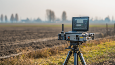
Getting a solid grip on the basics of GNSS RTK (Real-Time Kinematic) base stations is pretty important if you wanna get the best results, you know? The performance of a GNSS RTK system really depends on a few key things — like where you place the antenna, the quality of the signals you're receiving, and what's going on in the environment around you. I’ve seen data that shows if your antenna isn’t set up properly, your accuracy could drop by as much as 30%. But if you find a spot with a clear line of sight, you can boost your accuracy by up to 50%. So, it’s really worth taking the time to position that antenna carefully — avoiding buildings, trees, and other obstructions helps big time.

Aside from that, making sure your equipment is regularly checked and maintained plays a huge role in keeping things running smoothly over the long haul. According to a report from the International GNSS Service (IGS), a well-kept RTK system can give you positioning errors as low as 1-2 centimeters in real-time. Doing routine checks on signal quality and hardware can catch any issues early on before they turn into bigger problems. Basically, knowing your GNSS RTK stuff isn’t just nerdy talk — it’s how you make smarter decisions, which means more accurate surveys and mapping. It's all about understanding the tech so you're not caught off guard and can deliver the best results, every time.

Key Factors Influencing GNSS RTK Base Station Accuracy

When it comes to GNSS RTK (Real-Time Kinematic) base stations, their accuracy really depends on a bunch of different factors that anyone working with them should keep in mind to get the best results. One biggie is satellite geometry—that’s just a fancy way of saying where the satellites are positioned at any given moment. According to the folks at NOAA, having a good satellite spread can cut down positioning errors by as much as 20%. So, it’s pretty clear that using multiple GNSS systems like GPS, GLONASS, Galileo, and BeiDou makes a big difference in both accuracy and dependability.

Then there's the gear itself—things like antennas and receivers. The IAG points out that high-quality, multipath-resistant antennas do a great job at minimizing signal interference, which means better positioning. But don’t forget, environmental factors play a role too. Conditions like atmospheric disturbances, especially ionospheric delays, can cause errors of over 10 centimeters if the weather isn’t cooperating. Keeping your equipment well-calibrated and watching out for environmental conditions really helps in keeping those measurements spot-on. All in all, it’s pretty much about blending the right equipment, keeping an eye on satellite positions, and being mindful of the environment to make sure your GNSS RTK setups are working at their best.

Optimal Geographical Location for Your GNSS RTK Base Station

Where you place your GNSS RTK base station really makes a big difference in how well it works and how accurate it is. I came across a study from the National Geospatial-Intelligence Agency that points out how choosing the right spot can boost signal quality and cut down on multipath interference — which is super important if you want precise readings. Usually, the best spots are elevated areas that aren’t blocked by buildings or trees, giving the station a clear line of sight to the sky. That’s crucial because any physical barriers can mess with the signals, leading to those annoying positioning errors.

5 Essential Tips for Optimizing Your Gnss Rtk Base Station Performance

Plus, the European Space Agency has some interesting findings showing that stations set up at lower latitudes tend to get steadier atmospheric conditions, which helps keep the GNSS signals reliable. Turns out, placing your base somewhere between 30° and 45° latitude can give you the best reception, since these areas often have fewer atmospheric hiccups. So, if you’re serious about getting top-notch performance from your GNSS RTK setup, paying attention to the geographical spot really pays off — it can mean the difference between spotty data and highly reliable measurements for whatever you're working on.

Essential Equipment Upgrades for Improved GNSS RTK Results

If you’re really looking to get the best out of GNSS RTK, then upgrading your equipment is pretty much a must. One of the biggest improvements you can make is investing in a high-quality GNSS antenna. From what I’ve seen, switching to a multi-frequency antenna can really make a difference—especially in reducing signal issues caused by atmospheric stuff. The International GNSS Service (IGS) mentions that using antennas that support L1, L2, and L5 frequencies can boost positioning accuracy by as much as 30%. Not too shabby, right?

Then, there’s the base station’s receiver. Upgrading to a modern one with smart algorithms means it can process signals more smoothly and handle multipath effects better—something that’s super important when you’re working in places with lots of signal reflection, like cities. NOAA reports that newer receiver tech can bump up RTK positioning accuracy to around 1-2 cm, which is pretty critical for tasks like surveying or farming where precision really matters. And hey, don’t forget about power. Having a solid backup system ensures your data keeps coming in no matter what, even if the power goes out—that’s just good sense when you’re depending on it for serious stuff.

5 Essential Tips for Optimizing Your GNSS RTK Base Station Performance

This chart illustrates the impact of various equipment upgrades on GNSS RTK performance metrics, including accuracy, latency, signal strength, and reliability. Upgrading specific components can lead to significant improvements in overall system performance.

Effective Data Management Strategies for GNSS RTK Station Efficiency

When it comes to GNSS RTK base stations, good data management is really the backbone of solid performance. One thing that helps a lot is setting up a clear, organized system for collecting and storing data. This way, you keep everything accurate and accessible—whether you need to quickly pull up past records or access real-time info on the fly. Using cloud storage can be a game-changer because it makes data more accessible and adds an extra layer of backup, which is super handy—especially when you're working with a team on a busy survey project.

5 Essential Tips for Optimizing Your Gnss Rtk Base Station Performance

And don’t forget, regularly checking and cleaning the data is just as important. Periodic reviews help catch errors early, making your system more reliable overall. Plus, using good data processing software can really make your life easier by speeding up workflows and helping you make better decisions. Adding automatic validation checks can further bump up efficiency—they catch discrepancies before they turn into bigger problems. Follow these simple but effective data management strategies, and your GNSS RTK stations will run more smoothly and accurately, leading to better results in your surveying work.

Regular Maintenance Practices to Sustain GNSS RTK Performance

Keeping up with regular maintenance is super important if you want your GNSS RTK base stations to keep working accurately and reliably. One of the biggest things to check is the antenna—make sure it’s in good shape and properly aligned. Dust, dirt, or anything blocking the signal can really mess with reception. Giving the antenna a good clean and making sure it’s pointed in the right direction can make a huge difference, helping you avoid problems caused by nearby structures or trees.

Also, don’t forget about the software and firmware. Updating them regularly is key because it helps fix bugs and keeps the system running smoothly. It’s a good idea to peek at the performance logs now and then—this way, you might catch small issues before they turn into bigger headaches. By sticking to these simple maintenance routines, you can extend the life of your GNSS RTK stations and make sure they’re always performing at their best, day in and day out.

Exploring the Excellence of Japan's Topcon GM52 Total Station: A Comprehensive Surveying Solution

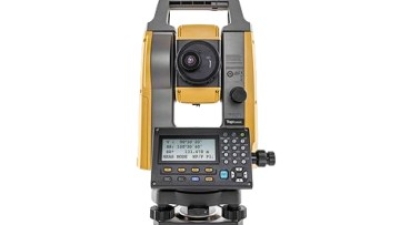
The Topcon GM52 Total Station stands out as a remarkable tool for the surveying industry, seamlessly integrating advanced technology with user-friendly features to create a comprehensive solution. With its integrated construction and survey application software, users can efficiently manage their data and streamline their workflows directly from the field. This feature is particularly beneficial for professionals who need real-time access to surveying results and project updates, enhancing productivity in construction projects.

One of the key advantages of the GM52 is its impressive electronic distance measurement (EDM) capabilities. It offers an accuracy of 1.5mm + 2.0ppm when using a prism and 2mm + 2ppm in reflectorless mode, providing precision across varying distances. The instrument supports reflectorless measurements up to 500m and prism ranges extending up to an impressive 4,000m. Additionally, the GM52 boasts advanced angle accuracy of 2”, ensuring reliability and precision in every measurement taken. The dual keyboard design in the 2” model enhances usability, allowing operators to work efficiently in different field conditions.

Further enhancing its appeal, the GM52 features Bluetooth communication for seamless data transfer to other devices. Its IP66 dust and waterproof rating ensures durability in challenging environments, making it ideal for professionals working in diverse weather conditions. Overall, the Topcon GM52 total station exemplifies excellence in surveying technology, combining accuracy, versatility, and reliability in a single robust instrument.

FAQS

: What is one important equipment upgrade for improving GNSS RTK performance?

: Investing in a high-quality GNSS antenna, particularly a multi-frequency antenna, is an important upgrade that can reduce signal degradation and improve positioning accuracy.

How can multi-frequency antennas enhance GNSS RTK results?

Upgrading to antennas that support L1, L2, and L5 frequencies can improve positioning accuracy by up to 30%, as indicated by research from the International GNSS Service (IGS).

Why are modern receivers important for GNSS RTK?

Modern receivers equipped with advanced algorithms can efficiently process signals and mitigate multipath effects, which is crucial for accurate positioning in urban environments.

What level of accuracy can new receiver technologies achieve for RTK positioning?

New receiver technologies can enhance RTK positioning accuracy to within 1-2 cm, which is essential for applications like surveying and agriculture, according to a NOAA report.

What role does a reliable power backup system play in GNSS RTK data collection?

A reliable power backup system ensures continuous operation during power outages, maintaining the integrity and reliability of GNSS RTK data collection.

What is a key data management strategy for GNSS RTK base stations?

Implementing a structured data collection and storage system is a key strategy that helps maintain data integrity and allows for easy access to both historical records and real-time data streams.

How can cloud storage solutions benefit GNSS RTK data management?

Cloud storage solutions enhance accessibility and provide backup capabilities, minimizing the risk of data loss and facilitating seamless data sharing in collaborative projects.

Why are regular data audits important for GNSS RTK systems?

Regular data audits help operators identify and rectify inaccuracies in data sets, improving the overall reliability of the GNSS RTK system.

How can data processing software improve GNSS RTK operations?

Employing robust data processing software can streamline workflows and enhance decision-making, thereby improving the efficiency of GNSS RTK operations.

What is the benefit of integrating automated data validation checks in GNSS RTK systems?

Automated data validation checks can flag discrepancies before they affect performance, optimizing the overall efficiency of the base station.

Conclusion

Getting your GNSS RTK base station running at its best is pretty important if you want more accurate and efficient results in your geospatial surveys. Honestly, understanding the basics of how these stations work is a good starting point — it helps you make smarter improvements down the line. Things like weather conditions, reflections from nearby surfaces (you know, multipath effects), and keeping your equipment properly calibrated can really impact how precise your positioning data turns out. Oh, and picking the right spot for your base station is key—going for a location that cuts down on interference and gives you clear signals makes a big difference.

Upgrading your gear can really boost your RTK outcomes, and having solid data management strategies in place keeps everything running smoothly. Don’t forget—regular maintenance is super important if you want your station to stay reliable over time. There are companies like Shanghai Apekstool (APEKS) that offer cool solutions and equipment to help with these optimization efforts. They can support you in meeting your surveying and mapping needs with top-notch accuracy and dependability.

Elena

Elena

Elena is a dedicated marketing professional at Shanghai Apekstool (APEKS), a leading provider of innovative geospatial surveying and mapping products. With a deep expertise in GNSS/GPS systems, total stations, levels, and theodolites, she plays a crucial role in communicating the core benefits and......
Previous Top 10 RTK Col Antenna Manufacturers from China at the 137th Canton Fair